Route 61 flows through Eastern central Pennsylvania like a frozen mountain stream, winding through the deep geologic folds of the Blue Mountains and the Allegheny Front. On a blisteringly cold January afternoon, patches of black ice sparkled like anthracite in the late sun, giving a lustrous and dangerous sheen to the pavement below us as we drove north out of Ashland. Like many boroughs in the region, Ashland's downtown is arranged in a grid pattern longer than it is wide, its growth constrained by the tight parallel mountain ranges that flank its northern and southern borders. Filled with weathered homes, crumbling storefronts and eroding culm dumps, this former coal mining town of three thousand people (and dropping) may not seem like a place of good fortune. But Ashland, Pennsylvania lies just a stone's throw from another town - a town that once served as a stark reminder of how much worse Ashland's situation could have been.
Through dark groves of beech, birch and hemlock, I carefully navigated up and down the winding two lane highway as my friend Kyle, who had spontaneously decided to tag along for a few days following my departure from Baltimore, wondered aloud from the passenger seat if perhaps my little four cylinder Tacoma might be in over its head on these steep, snowy back roads. The truck seemed to agree, fishtailing for a split second as we rounded another turn. A high-pitched beeping filled the cab as the traction control kicked in; Kyle shot me a sideways glance and tightened his grip on the passenger door handle, no doubt wondering if he might've been better off catching his original flight back to Memphis.
White snow and whiter knuckles
(Source: The author's own)
We continued up the road until, suddenly, a dull yellow sign emerged from around the bend and centered itself directly in front of us. Emblazoned across the sign was a black arrow peppered with buckshot, indicating that the road took a sudden, sharp turn to the right. A steep drop-off below the outside lane revealed that this portion of the highway was built on fill material instead of being cut into the earth, as though it were added later as an afterthought. Behind the sign, two low mounds of earth and rubble dotted with pine saplings formed a physical barrier against approaching vehicular traffic.
As the truck groaned up hill, I could see the open tree canopy behind the berms, suggesting that the highway had, at one point, continued straight ahead. On a treacherous mountain road like this one, what could possibly justify such an extensive (and expensive) re-route? To understand, we have to go back over half a century, to 1962. That was the year when Centralia, Pennsylvania began its descent into the history books as one of America's most famous ghost towns.
I can't remember how Centralia first came to my attention but my obsession with it was immediate, likely because nowhere else on this Earth do so many of my interests converge in one spot - geology, danger, abandoned things and accidental fires.
The area around Centralia is littered with the remnants of once-productive strip mines. Piles of waste coal (colloquially known in eastern Pennsylvania as "culm") mixed with rock fragments were often discarded on the outskirts of town or dumped into ravines. Over time, these dumps naturally evolved into impromptu landfills, as locals took advantage of the otherwise useless land by discarding their household waste down the steep slopes. Every so often, when the mounds of trash reached critical mass, the local fire department would come along and set them on fire - a quick and easy solution in the days before environmental regulations.
Though a number of different theories exist to explain how the Centralia fire began, the most commonly accepted is that an improperly extinguished landfill blaze crept into one of the many abandoned mine tunnels that criss-cross below the town, igniting a coal seam. With a steady supply of oxygen and a practically endless source of fuel, the fire spread deeper and deeper into the earth with few, if any, obstacles to slow it down.
Local officials knew of the fire almost from day one but, due to the complexity of the problem, there was little they could do, aside from drilling a serious of boreholes around the city to monitor the fire's spread.
A monitoring well covered in grafitti.
(Source The author's own)
Suggestions on how to control the blaze varied widely. One idea involved pumping a slurry of water and crushed rock into the shafts; another proposed encircling the blaze with an excavated trench, then back-filling it with some sort of noncombustible material. However, without an accurate way to determine exactly how far-reaching the fire had become, none of the proposed ideas proved successful.
For the most part, Centralia's residents knew nothing about the mine fire - or at least, nothing of true magnitude. Then, in 1979, the owner of a local gas station noticed something unusual when he went to check the fuel level of one of his underground tanks: the dipstick came out hot - very hot. A subsequent thermometer reading showed the temperature of the gasoline in the tank to be almost two-hundred degrees Fahrenheit.
Word of the fire gradually spread throughout the region, eventually reaching a national level when, in 1981, a twelve-year-old boy playing in his backyard was swallowed by a sinkhole four feet wide by one-hundred and fifty feet deep. Miraculously, the boy survived by clinging to a tree root until his cousin could pull him to safety. Examinations of the sinkhole revealed plumes of hot steam containing lethal levels of carbon monoxide.
By this point, there could be no denying it - Centralia was dying.
We pulled off the highway and parked next to the larger of Centralia's two cemeteries, the final resting place of the parishioners and family of the Saints Peter and Paul Russian Orthodox Church. A scattering of empty aerosol paint cans and glistening, ice-filled footprints guided us along a worn dirt path that crisscrossed around gnarled oak trees and chunks of broken asphalt. The ground here is pockmarked with dips and depressions, like the remnant craters in a recovering war zone; as the underground coal seam burned away, the earth above it settled unevenly into these newly created subterranean voids. Nowhere is this bizarre morphology more apparent than on the surface of what's come to be known as Graffiti Highway, the three-quarters of a mile long stretch of Route 61 around which we'd detoured on our way into town.
From its origin at the landfill, the underground fire slowly spread from one coal seam to another, eventually forming at least three different "fronts." Taken using a thermal camera, the aerial image below shows the path of these fronts - the white "hot spots" indicate areas where the fire is burning close enough to the surface to create a detectable temperature gradient.
For reference, the cemetery where we parked is located in between fronts 1 and 2, right where the two highway sections converge.
(Source: CentraliaPA.org)
One such front, labeled on the map above as "Fire Front 2," stretches below the original portion of Highway 61. Due to the uneven settling of the earth below it, the once consistent grade of the pavement now ripples and bucks like a roller coaster. In at least one location, the ground has subsided to such a degree that the asphalt is literally being ripped apart, creating fissures up to a foot wide and equally deep. In years past, one could observe steam radiating from the soil below, though I believe the portion of the seam that is actively burning has now migrated further to the west, out from under the highway and into the surrounding woods. Knowing what had happened to that boy in his backyard, we decided it would be best not to stray far from the road (Gabby, of course, stayed in the truck).
Stepping around the wide, shallow craters and spent cans of spray paint, Kyle and I clambered over an ice-covered berm similar to those we'd passed on the southern end of the highway. It's here that the re-routed section once again joins the original road. From atop the berm, we gazed out over an eerie length of undulating, abandoned highway that was covered - and I mean absolutely covered - in graffiti dicks.
Exhibit A
(Source: The author's own)
Though a recent storm had blanketed much of the pavement in soft, powdery snow, large swaths remained uncovered due to the radiant warmth from the burning fires below. Extrapolating from what I could see on the exposed patches of asphalt, there must have been upwards of 1,000 dicks of every size, shape and color stretching all the way to the horizon, for just shy of a mile (for the full effect, do a quick Google image search for "Centralia graffiti dicks" and prepare to be amazed at the sheer tenacity of rural teenagers with nothing better to do with their time).
The largest (and most photographed) fissure is located about halfway down the road, so we slipped and slid down the icy pavement, each having the opportunity to point and laugh at the other for falling backwards onto our respective behinds. Upon reaching The Crack, we felt humbled, pausing for a moment to reflect on its awesome splendor.
"That's it?"
"Yep."
"Huh. I'm going back to the truck."
(Source: The author's own)
Next up on our tour was "Fire Front 1," the most active of the burning seams. Though not as prominent as I'd expected, we did witness a couple of faint steam whiffs emanating from the earth, accompanied by a noticeable twinge of sulfur in the air. Based on photos I've seen online, some of these plumes can be quite significant but likely due the creeping nature of the fire, these "activity areas" are always changing, extending deeper and deeper into the forest.
(Source: Atlas Obscura
After a brief foray into the woods, we decided to throw in the towel - even if we did stumble across an active plume, it would soon be too dark to see it. Dusk was coming quickly, so we opted to use what little daylight we had left to cruise around "downtown," which now exists just as an empty grid of ice-covered streets, overgrown lots and a few crumbling stone walls. It's hard to believe that, only a few decades ago, this was a thriving coal town with over a thousand residents. Now, that number is less than ten.
(Source: The author's own)
In 1982, twenty-two years after the Centralia mine fire began, Congress allocated some $42 million to assist with the relocation of the town's residents. While most of the population accepted the buyout and moved to nearby communities (Ashland being one of them), a handful of families dug in and vowed to stay put. With varying degrees of success, they petitioned the Pennsylvania state government and challenged its seizure of all properties in the city through eminent domain. Finally, in 2013, the remaining seven residents reached an agreement with state and local officials - they would be allowed to live out the remainder of their lives in Centralia, after which their properties would be taken through eminent domain and razed.
This final holdout is all that remains after the row houses adjacent to it were demolished. Brick pillars lend support to what was never intended to be a freestanding structure.
(Source: The author's own)
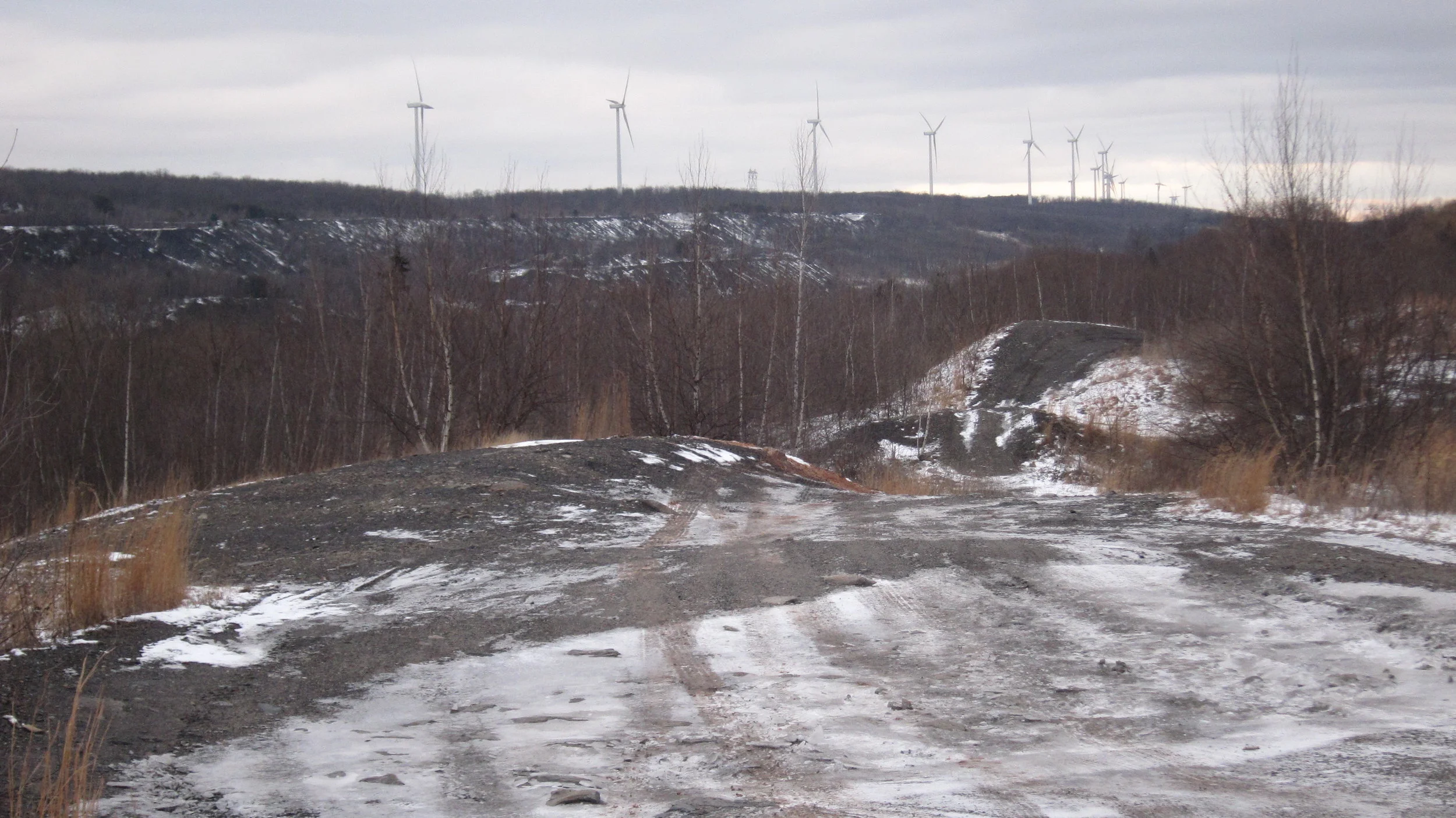
As we side-stepped our way back to the truck, dodging patches of ice and slabs of waste coal, I noticed something on the horizon that had somehow escaped my attention earlier.
(Source: The author's own)
Towering some three hundred feet tall, a colonnade of wind turbines stood at attention across a distant ridge, perhaps two dozen or more stretched out over several miles; despite the vast distance between them, a warning light atop each tower blinked in unison with the rest. The pulsing red beacons radiated through the misty night sky like fire, bathing everything in the valley below with an ominous ruby glow - much like the light from a coal fire.
With any luck, by the time the last fragments of anthracite have smoldered to ash, these Pennsylvania mountains and others like them might host enough wind turbines to render coal mining obsolete. But as we continue to march inexorably toward that cleaner future, our once dirty past will continue to haunt us; by some estimates, the coal seams below Centralia may contain enough fuel to burn for another two-hundred and fifty years.
Pulling out onto the dark highway from one of the town's many abandoned side streets, the truck fish-tailed again, kicking up an icy slush of snow and dust. The valleys here seem to absorb any and all available light, especially on an overcast night like this one. As we carefully made our way back down the winding mountain road toward our next destination, the day's snowmelt was already starting to refreeze, scattering a warm glow in the headlights like the lucent shine of burning coal.
CWO